Brooklyn Heights in the Path of Hurricane Irene

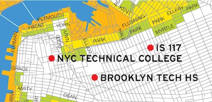
It’s still three days away, and the path it follows changes continually, but the current (Thursday afternoon) “center” track of Hurricane Irene is now projected to pass through Brooklyn and Manhattan, and the eye could potentially go right over the Brooklyn Heights Area. The current expectation is that the Hurricane (it may be a less-powerful tropical storm by the time it gets here) will arrive sometime on Sunday, but the initial impact of wind and rain could hit the neighborhood earlier. The NYC Office of Emergency Management has announced that it will decide shortly whether to call for evacuations of low-lying areas prone to flooding, including One Brooklyn Bridge Park, Fulton Ferry, DUMBO and Vinegar Hill (the orange, yellow and green bands on the map show potential flood areas based on an increasingly strong storm impact; NYC Technical College and Brooklyn Tech HS have been identified as potential evacuation sites).

Residents in the path of a hurricane or tropical storm should be prepared to either evacuate or shelter in place at home or in designated shelters, with adequate food, water, batteries for flashlights and radios, and other necessary supplies. Information on preparing for a hurricane is available at OEM’s website. Information on the status of the hurricane will also be posted on the Brooklyn CB2 CERT Team website.

Check to FEMA Flood Zone Map to see if how at risk your block is here.

NYS Senator Daniel Squadron offers Hurricane Irene related links here.

Share this Story:

, , , , , ,

  • nabeguy

    Looking at that map, I’d say that Bubba’s will have to change its name to Bubbles.

  • RemsenGal

    Thank you for the up to date and helpful information. There’s a lot of it out there, so thank you for boiling it down for us. Good to know.

  • Andrew Porter

    Didn’t see this topic here when I just posted this on the Open Thread.

    Worst case scenario: hundreds of trees down, windows broken, some old buildings—especially 192 (194?) Columbia Heights, other old and vulnerable brownstones—collapsed. Wind tunnel effect around taller buildings in BH may pick up sidewalk sheds and other construction materials, and throw them down the street. Massive storm surge could wipe out Brooklyn Bridge Park, which is only 9 feet above mean high tide. Large parts of DUMBO could be under water—the new housing for the Carousel could be washed away, and many streets and low lying stores and homes inundated. Empire Stores, never in great shape, could collapse.

    This could be the most destructive thing to happen to BH in our lifetimes. And no, I don’t think I’m being overly pessimistic.

  • cfb

    Bear is mind that the storm is likely to lose some punch as it comes up the coast; still a force to be reckoned with, but the wind impacts may not be as risky as the rain.

  • stuart

    last I heard the eye is likely to pass over eastern Long Island. We will get torrential rain and wind gusts to 50 mph, which can be damaging to trees.

  • AEB

    To find out EXACTLY whether your neck of the BH woods is evacuation-designated, and under what storm conditions, first go here:

    http://propertysharp.com/mason/ny/New-York-City/Maps

    Next, click on Get More Maps, green bar at bottom left;

    scroll down the left-hand double-columns, find Hazards and Environment in the left-most column, and check-off Hurricane Evacuation Zones in it;

    mouse onto the general BH and area and keep zooming in, adjusting the map directions as you do, until street names appear;

    find yours and check out the coloration: white means no need to evacuate no matter how fierce the storm. Otherwise, colors correlate between storm severity and need to evacuate, the darkest equaling the most severe storm.

  • Eddyenergizer

    Andrew Porter, Wow! you should write scrips for Hollywood disaster movies, The best part is “the new housing for the Carousel could be washed away”, if no one got hurt, that would be a blessing ;)

  • Wallard

    I’m laying odds that Time Warner Cable will pre-emptively drop all service effective Friday night, and FIOS will continue to remain elusive to most BH residents.

  • AmyinBH

    Anyone have a non-fiction version of how the neighborhood was during and after one of the last big hurricanes (Bob 1991 or Gloria 1985)?

  • WillowtownCop

    So if this is anything more than pure hysteria to drum up news, how many idiots will go out to the promenade with their cell phones trying to film BBP underwater, forcing rescue personnel to go out after them?

  • MaryO

    If you live in an evacuation zone, MAKE ARRANGEMENTS FOR YOUR PETS. You cannot bring them into shelters, as they are prohibited due to health and safety concerns.

    Also, those shelters indicated on the map will not be open _unless_ it is publicly announced. They are there for reference only, and are only activated on orders of OEM.

  • http://loscalzo.posterous.com Homer Fink

    @aeb – i linked to FEMA flood map above, it goes directly to a view of Brooklyn Heights.

  • Erik

    Does anyone know where I can get some sandbags in the area? I live in a garden apartment and want to be cautious. thanks.

  • Eddyenergizer

    AmyinBH Gloria in 85. friends threw a “hurricane party” We had a great view from their apartment on the 25th floor of 140 Cadman Plaza. All in all not much happened here, a few tree branches came down, some trash cans were strewn about and the rain was very heavy, but as I recall, no serious damage in the Heights. One thing I remember, seeing the striated bands of clouds in the sky.

  • AmyinBh

    Thanks Eddyenergizer. I was wondering just what to expect (blackout conditions, falling debris, etc.). My experiences with the past major hurricanes were in the suburbs near the coastline and much worse than what you described.
    Fingers crossed it goes out to sea.

  • Andrew Porter

    1938 hurricane devastated Long Island, southern shore of Connecticut and Rhode Island. Remember all those people who poo-pooed the possible impact of Katrina?

    Here’s info about the Long Island Express of 1938:

    http://www.erh.noaa.gov/box/hurricane/hurricane1938.shtml

  • AEB

    Homer: oy!

    Here’s another link that seems more BH-friendly:

    http://gis.nyc.gov/oem/he/index.htm

    courtesy of Se, Squadron….

  • lois

    We have had a dead tree limb hanging off a tree opposite 214 Columbia Hts for several months – called about it and was told they check trees every seven years but will come if the limb or tree falls down. Yesterday, the large limb was hanging dangerously over the sidewalk, ready to fall on somebody’s head. We called 311, 911, NYPD, NYFD, and were continuously referred to the Parks Dept who said they would come in 7 days. Our thanks to two gentlemen who finally took matters into their own hands (during the rain), roped off the area, pulled down the limb and removed it. So much for the reports on the news that Parks Dept was responding to take care of these matters.

  • nabeguy

    Erik, if there’s any left, go to either Home Depot or Lowes and look for sand in the Masonry section. They only come in 50lb bags so you might want to hit up Gristededs and steal a few plastic bags (and remember to get enough to double bag them!).

  • Bette

    I think it’s not so much the effects of wind and heavy rain (although for sure there will be flooding) but even if BH is not affected directly, the indirect effects could be pretty crummy.

    We should be aware that subways might get flooded, making movement into Manhattan difficult (or movement out of Manhattan back to your home in BH impossible), power outages (no lights, no refrigerator, loss of air conditioning for the hot days after the hurricane), road closings, and as someone above mentioned , loss of cable TV (children going nuts in the house from boredom!).

    Also a small chance of loss of water services – get some water to drink and to dump in your toilet!

  • Montagueresident

    Scared to death about that giant scaffolding at 62 Montague. Lets hope it is secured properly. Montague Street to begin with is a wind tunnel, no add 90mph winds to that,…..

  • Montagueresident2

    I can see the roof of 66 Montague from my apt. They have a dozen or more large plants growing in tubs and other debris. Could be flying missles.

  • Ari

    Even in a worse case scenario, from a flooding/storm surge perspective, this area of Brooklyn is strategically lucky due its relatively high elevation from the shorelines. Basically from Middagh to Atlantic Avenue, Columbia Heights is elevated at least 52 feet at it’s lowest point from the Furman street shoreline level (which is generally 10 feet above the shoreline). Willowtown too is about 55 feet above the shoreline. Remarkable considering how many low laying areas there are along all the shores of NYC.

    However, this elevation totally also exposes Brooklyn Heights to wind coming from the south east, which is where this Hurricane’s winds will be blowing in from. Or so says the hype…

  • John Laskin

    nabe guy is still as obnoxious on the island as he was in BH. So happy you are gone, blog about your new neighbors, I am sure you have many things to say already.

  • Willow St. Neighbor

    Nabeguy is not obnoxious at all.
    I cannot get over the mean spirited people who post here.

  • Gerry

    We took off got the heck out of town packed up our car and drove north to Westport, Ct. up here the rain and winds are fierce but we are safe and dry inside until the storm is over. The traffic was very heavy!

  • TD

    I think many Heights residents have terribly overreacted to the hurricane threat. We are not in a low-lying area near the water. That;’s why it’s called Brooklyn.Heights. Yesterday evening’s crowd at Key Foods was laughable. At least there was some beer left for me.

  • David on Middagh

    TD, I think there was a chain reaction. Mayoral caution –> no public transportation –> employees can’t commute –> stores announce closure –> Saturday and Sunday shoppers go on Friday.