If you want to take a look at the rare 1770 map of New York City, which includes Brooklyn, discovered by the Brooklyn Historical Society among items that had been held in storage, you’ll need to go to the Society’s Othmer Library, located in their building at Clinton and Pierrepont Streets, this afternoon or next […]
Tag Archives | 1770 map
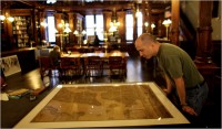
Rare 1770 Map at Brooklyn Historical Society
The New York Times has an article about a rare map of New York City from 1770; it was discovered at the Brooklyn Historical Society last year, and is one of only four such maps created by the venerable cartographer Bernard Ratzer. Almost as intriguing as the map itself are the steps that were involved […]

Nabe Chatter