The postwar brought the great era of modernism and social engineering. A nation flush with victory and wealth thought it could solve any problem and enthusiastically looked forward to, and even worshipped, the future (probably because the immediate past had been so bad). A bright, modernist future beckoned.
At the same time there was a housing shortage, which became clear when families that had doubled up during the Great Depression and put off marrying and having children, now wanted, and, unlike after World War I, could afford their own dwellings. There had been little residential construction during World War II.
As manufacturing and shipping moved to the suburbs due to the ascendancy of trucks, a new population exodus began with the construction of Levittown in the potato fields of Nassau County.
Brooklyn’s population reached almost 2.8 million in 1950, a level it would never again attain (it has come back to 2.5 after falling to two million in 1980). Aircraft manufacturers that had grown up on Long Island before and during the war, such as Grumman and Republic, needed new workers for Cold War contracts. But this time the out-migrants were not replaced by foreign immigrants.
The results of these social changes and the war were the baby boom, the institution of permanent rent controls, and urban renewal, and the replacement of old, declining areas with new housing and offices, as federal dollars provided by the Housing Act of 1954 began to flow to the endangered cities. New York City began its own housing programs for the middle class and poor to prevent its abandonment.
In the 1950s, per the site demolition plan outlined in 1944 and later, the eastern half of the block between Montague, Pierrepont, Clinton and Fulton Streets was condemned, as was the entire one to the north bounded by Pierrepont, Clinton and Fulton Streets. This was the part of the Downtown plan that affected the Heights. But the new buildings were not as specified in 1944; they were to be private, not public, since federal funding was no longer available.
The urban renewal plan was described in the Cashmore/Moses paper as follows:
It is not a visionary picture of the glorified ‘city beautiful’ type. It is a practical, realistic program to provide adequately for the movements of existing and future traffic, to make available desirable sites for necessary public buildings and to clear away blight and restore property values, on enterprise to participate in the redevelopment of the section in conformity to a comprehensive, integrated plan.

The well-known architect and critic Lewis Mumford stated in an article in the New Yorker magazine on April 25, 1953 titled “From Blight to Beauty”:
It is the biggest piece of redevelopment the municipality has ever attempted. If well done it will provide a positive example for the reconstruction and modernization of the rest of the city.
The Brooklyn Union Gas Company moved to 189 Montague Street, between Clinton and Court, a new building constructed on the site of the Brooklyn Mercantile Library as part of the urban renewal project, and which now serves as the offices of Sovereign Bank, a U.S. subsidiary of Spain’s Banco Santander. This bank had formerly been the Brooklyn-based and community-oriented Independence Community Bank. In the 1980s, when the gas company took over the failing Long Island Lighting Company, it changed its name to Keyspan and moved to a new building in Metrotech on Jay Street. Keyspan later became National Grid, a U.S. unit of the British company of the same name that operates that nation’s electric and gas transmission systems.
St. Francis College began as a grade school and started giving degrees in 1884. In 1902 the primary and secondary divisions became St. Francis Academy. It moved to Remsen Street in 1962 from 35 Butler Street, into the two former headquarters buildings of the Brooklyn Union Gas Company at 176 Remsen. The college razed the Greek Revival first gas company building in 2004 to construct a new classroom and library building dubbed the Frank and Mary Macchiarola Academic Center for its former president. As a precaution, the second former Gas Company building was granted landmark status in 2011.
St. Francis now occupies almost the entire southern side of Remsen Street between Court and Clinton streets. In the 1960s it had several buildings, including the William Hester townhouse, razed in order to construct a large new building. St. Francis also built a teaching brothers residence on neighboring Joralemon Street to replace the Behr house at Henry and Pierrepont streets, which it sold in 1976.
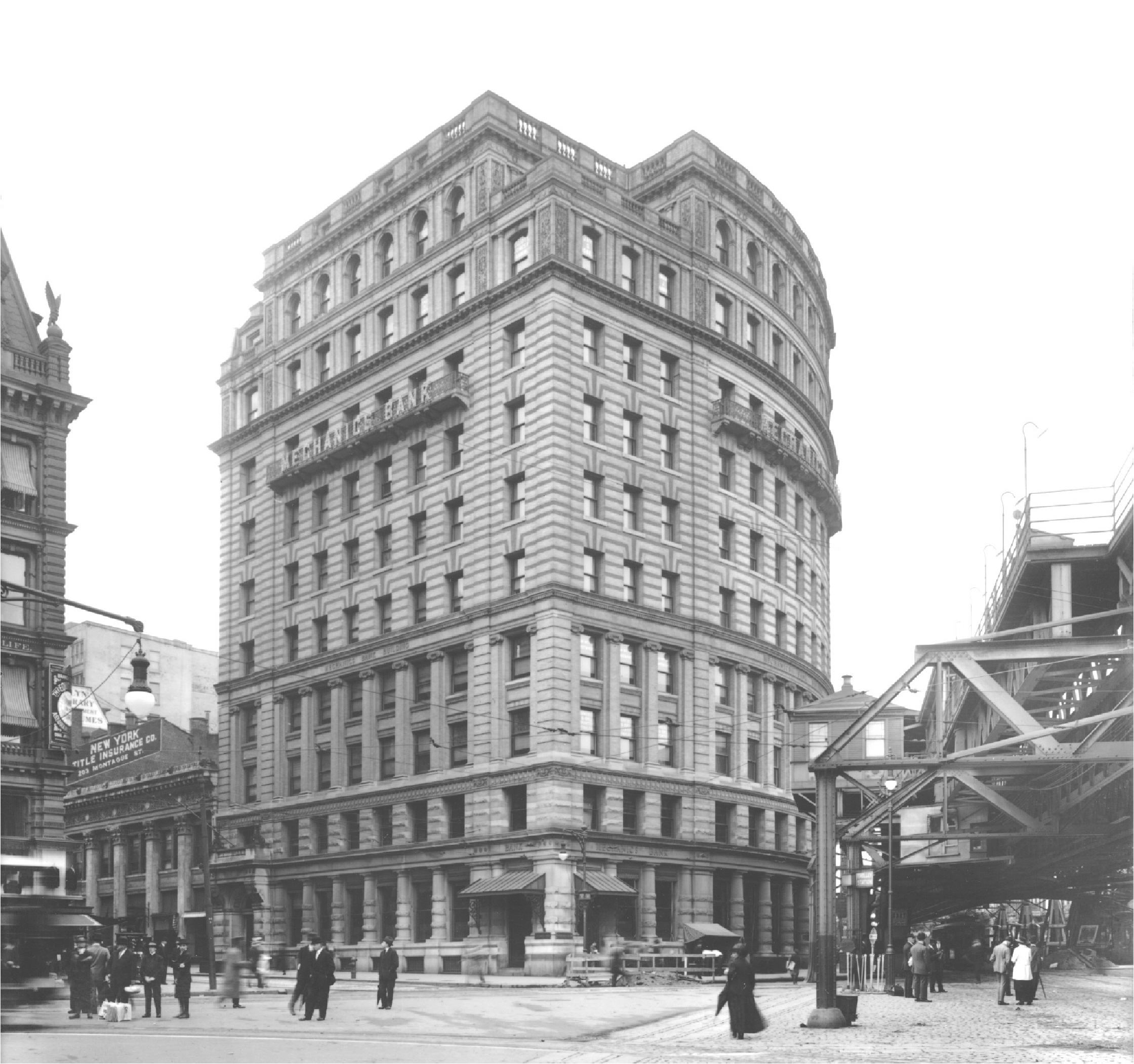
During the late 1950s and early ’60s the easternmost block of Montague Street was greatly altered, with the Mechanics Bank Building on the north side being demolished in 1959. Joe’s Restaurant, still famous (like Lundy’s of Sheepshead Bay) for its shore dinners, which was next to Mechanics on the Pierrepont Street side, fell the same year. In the 1960s, a new four-story home for the Brooklyn Savings Bank was built at Montague and Cadman Plaza West. It is this building, now occupied by TD Bank and Massey Knakal Real Estate, which carries the plaque honoring Jackie Robinson and Branch Rickey, although the momentous event took place in the Mechanics Bank Building which stood there previously.
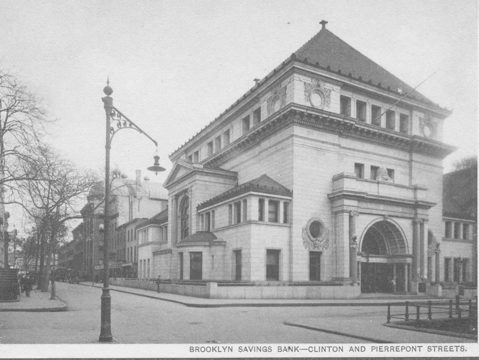
The Brooklyn Savings Bank, on the northeast corner of Clinton and Pierrepont streets, was torn down because it, too, was old. The site remained vacant until the 1980s when One Pierrepont Plaza, a back-office building for Morgan, Stanley and other companies was erected there.
The area from Henry, Clark and Fulton all the way up to Old Fulton Street at Middagh was officially deemed blighted by Robert Moses’ Slum Clearance Committee in the late 1950s and condemned, along with the southern side of Clark Street between Monroe Place and Fulton Street, in part because the former Church of the New Jerusalem on the corner of Monroe Place was abandoned.
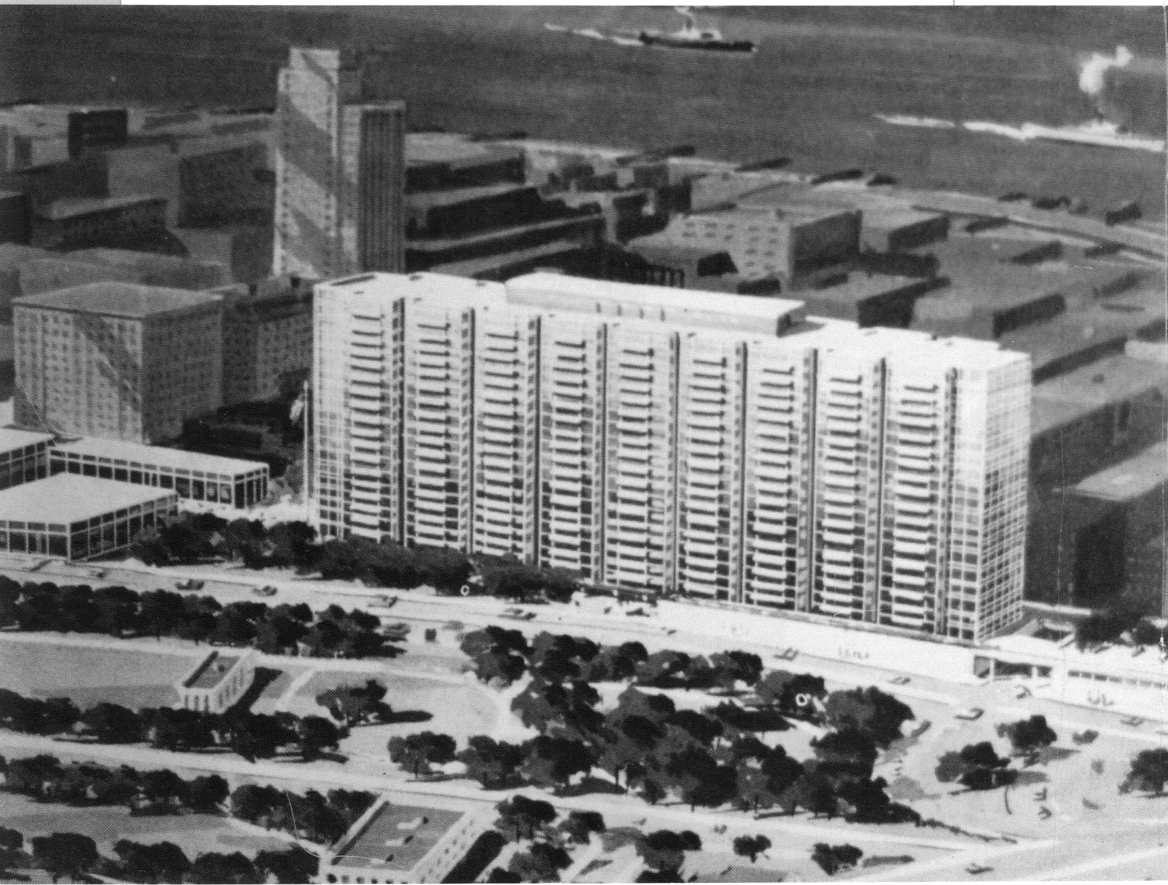
In the 1960 Census, of the 366 dwelling units on the west side of Fulton Street between Clinton and Henry Streets, sixty percent of the apartments were deemed “substandard and unfit” (because poor people lived there). This was crucial because such a finding was a precondition for obtaining federal funds for site acquisition for slum clearance under the Housing Act of 1949. The result supported Robert Moses’ 1959 proposal to tear the area down and replace it with a four-hundred long twenty story building (see a rendering of this proposed building above) between Clark and Poplar Streets with garages, of which 64 percent would be “luxury” studios (then called “efficiencies”) and one-bedroom apartments.
Unlike the earlier Downtown scheme, the Cadman Plaza plan engendered massive local opposition. Seeking to identify with neighborhood stability, residents characterized the plan as a “dormitory for transients.” Perhaps most significantly, the Community Conservation and Improvement Committee (CCIC, pronounced “Kick”) found alternative developers willing and able to build on the community’s terms, demonstrating the practicality of its ideas. One of them, Mutual Housing Sponsors, would develop the northern site with its townhouses, while the Moses backed Sean Pierre Bonin would build the traditional high-rise southern element.
On April 11, 1959, the CCIC held a mass meeting at the Hotel Bossert attended by four hundred residents that roundly condemned the plan. By wrapping themselves in the cloak of being pro-family, because they wanted two-bedroom apartments, the preservationists made opposition by politicians difficult. The Brooklyn Heights Association and both political clubs also agreed. Feeling how the political winds were blowing, the normally silent but powerful Democratic district leader Frank Cunningham said “How can the Heights develop if they don’t give the young families a chance?” Development powerhouse Roger Starr, head of the Citizens Housing and Planning Council, supported giving the neighborhood alternative due consideration. Most significantly, Borough President Cashmore turned neutral on the project.
By the late 1950s, however, with preservationism becoming influential and with the federal law’s amendment in 1954 allowing “the rehabilitation and modernization of existing housing” as an alternative to site clearance, the city’s Housing Redevelopment Board called for a different approach. In addition, in response to opposition to a twenty-block urban renewal plan between 87th and 97th Streets on the Upper West Side of Manhattan, Mayor Robert F. Wagner had commissioned a report in the mid-1950s that supported housing rehabilitation as at least a partial alternative to site clearance. In 1956 Planning Commission chair James H. Felt said that “rehabilitation was a practical, desirable and economically feasible approach” to improving the area in question. Moses, however, had “grave doubts of the financial feasibility of the rehabilitation of brownstone structures.” Thus preservation acquired administrative respectability, and with the adoption of city law that allowed “rehabilitation and conserving” of old buildings during urban renewals, a legal structure for enactment. This was part of Mayor Wagner’s desire to ease Moses out of office in preparation for his 1961 re-election campaign as a “reformer.” On March 1, 1960, Moses withdrew from urban renewal, a huge victory for preservationists.
In February, 1959, an architectural consultant to the City Slum Clearance Committee stated that they were considering adding half of the block on the east side of Monroe Place down to the apartment building at No. 24 to the urban renewal area. (In point of fact, it had always been considered part of the proposal because it was a block from Fulton Street and mostly consisted of townhouses.) The community fought back and stopped the project at the church and its rectory (8 and 10 Monroe Place). An interesting footnote to this is that, according to Martin Schneider, neighborhood activists sought to induce Congregation Mt. Sinai, then based in Boerum Hill, to move into this building, and obtained the city’s support for the plan, which was unsuccessful.
Community groups proposed saving some buildings and providing middle-income (Mitchell-Lama) cooperative apartments. In response, in 1961 the city proposed a mix of townhouses and middle-income highrises. This proposal was accepted because the Brownstoners perceived that the entire project was too far along to be stopped.
That same year an outside alternative was presented that threatened the accommodation the community had reached with the city. Columbia University professor Percival Goodman, brother of social planner Paul, proposed adding low-income housing and a new PS 8 to the mix. This was in response to the battles over school integration being fought in the south, especially in Little Rock, Arkansas.
At that time many people felt that neighborhoods should be racially and economically integrated, and that government power should be used to effectuate it. School busing came into force in both directions between the predominantly black and poor Fort Greene projects and white and wealthier Brooklyn Heights. (Formerly wealthy Fort Greene became the poorest neighborhood in the city in the 1960s.)
There was much hand-wringing and liberal guilt, especially among parents of young school-age children. There was a real issue, however, with regard to where children should be educated, with many wanting public education for its democratizing ability, but perceiving that PS 8 was inadequate. There were enough wealthy brownstoners to support a new private school, and St. Ann’s was founded in response to this is 1966. As in other areas, schools, like retail, improved in response to local conditions, so that PS 8 eventually became a good school.
In 1961 Milton Mollen, chairman of the city’s renamed Housing and Redevelopment Board, the new incarnation of the Moses Slum Clearance Committee, opposed the plan in part because enabling federal funds had dried up.
The project was built in two parts: first, in 1967, north of Middagh Street, the Cadman Plaza North apartments, designed by Morris Lapidus, architect of flamboyant Miami Beach hotels such as the Fontainebleau. The part between Clark and Middagh Streets was designed by William Conklin, of L. William Glass and Whittlesey and Conklin, along the lines suggested by the community, with the Whitman Close Townhouses added to soften the impact of the massive highrises. Construction of this portion, designated Cadman Towers, began in 1973.
The urban renewal project included the widening of local streets to accommodate the additional traffic expected from the adaptation of the Brooklyn Bridge to the automobile. In the 1960s Fulton Street, whose name had been changed to Cadman Plaza West in 1967 (Washington Street became Cadman Plaza East north of where it begins at Johnson Street), was widened on both sides following the demolition of all of the buildings abutting it north of Montague Street. This turned out to be overkill in that Cadman Plaza West never carried the number of cars the widened street could bear, and it just shifted the heavy traffic to Court Street, which could not be widened. Consequently, Henry Street became the major southbound thoroughfare since it did not possess the Court Street bottleneck.
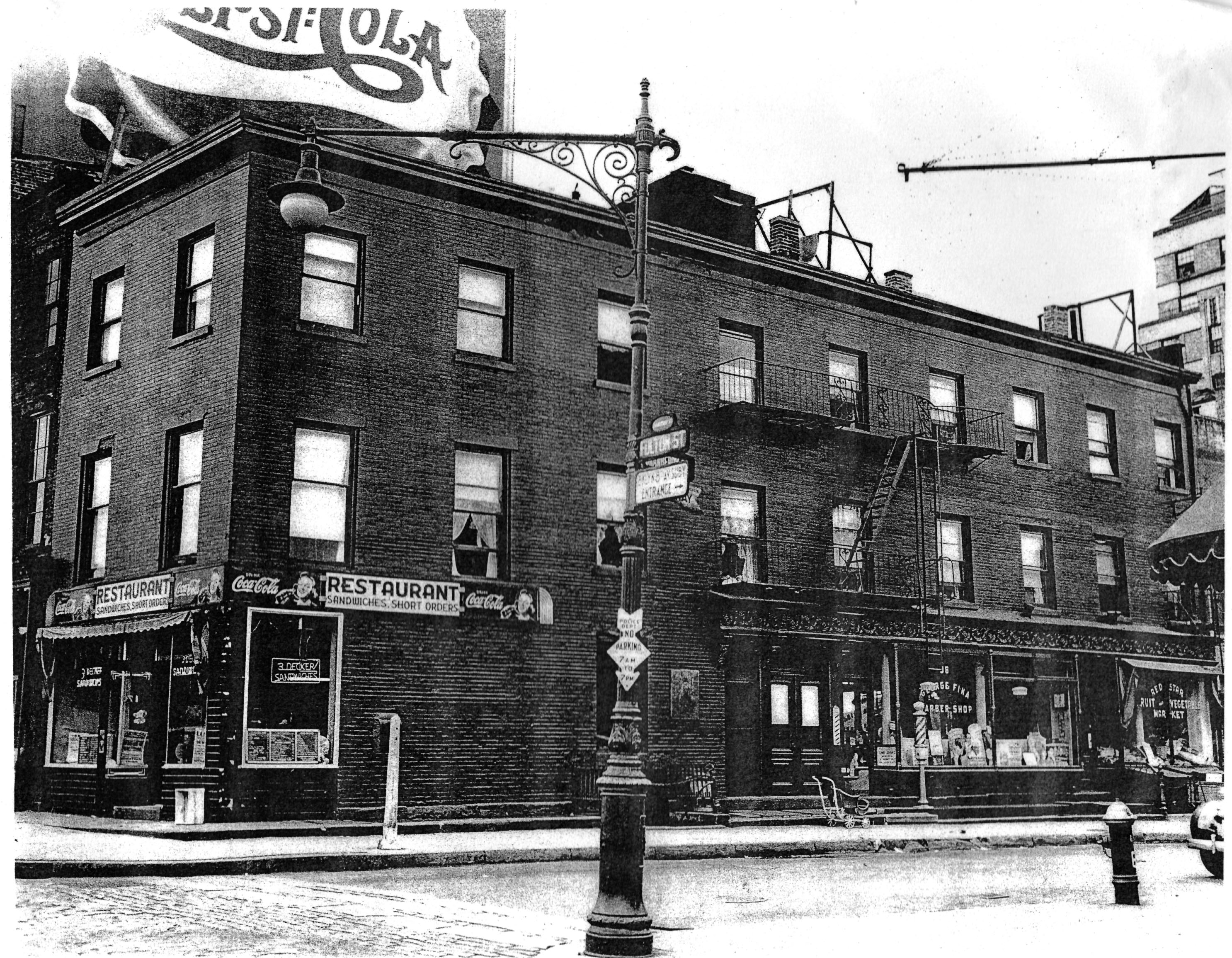
Notable victims of this portion of the urban renewal project included the building on Fulton and Cranberry Streets, which was once Rome Brothers Print Shop, where Whitman’s Leaves of Grass was first printed in 1855, and which was marked by a lovely art deco plaque placed by the Authors’ Club. This important structure in a pleasant area was replaced in the pursuit of what we now perceive as high-rise suburbanized modernism but was then the ideal of a city in a park, exemplified by Tudor City and Stuyvesant Town in Manhattan, perhaps the best local examples. Today we look at it in the quaint Heights and say “What is this doing here?” It is shocking how much upper Fulton Street resembled today’s chic Henry Street.
The Cadman Plaza Development was not the only new construction in the Heights done under the name of urban renewal. As noted, both sides of the upper block of Clinton Street between Pierrepont Street and Cadman Plaza West were condemned and these buildings were replaced by modern apartment buildings, the Business Library, and parts of the Cadman Plaza Development proper. Truman Capote described another local institution, an antique store called Knapp’s, at Fulton near Pineapple Street. It was the sort of old-fashioned warren of musty shelves in small rooms typical of New York in the 1950s and so rare today. Since it was in one of the group of buildings on upper Fulton and Henry Streets, it was demolished in the urban renewal.
This was one of the largest urban renewal projects ever undertaken, and to us it seems disastrous for destroying the urban fabric and vitality of upper Fulton Street and numerous notable buildings. Attitudes at the time were anything but sympathetic to preserving old buildings. Lewis Mumford, the leading Modernist critic, planner and architect, described the area as “covered by grimy buildings waiting for vandalism or the wrecker’s ball to level them.” It is doubtful that sandblasting them would have changed his mind.
NYC “reform” Comptroller Joseph McGoldrick called the project “a program of complete rejuvenation as well as the removal of the blight from this mongrel area.” While parts of the area certainly were blighted, calling it “mongrel” recalls Nazi racial theories or at least suggests a lack of respect for the stylistic diversity of tracts of old buildings and a preference for modernist uniformity.
Appropriately and strangely enough, Robert Moses in 1955 averred that it would be “to Brooklyn what the great cathedral and opera plazas are to European cities. It would be as much the pride of Brooklyn as the Piazza San Marco is the pride of Venice and the Place de la Concorde the cynosure of Paris.” Pride of authorship aside, these remarks suggest he had an aesthetic tin eye, or was just hyping it.
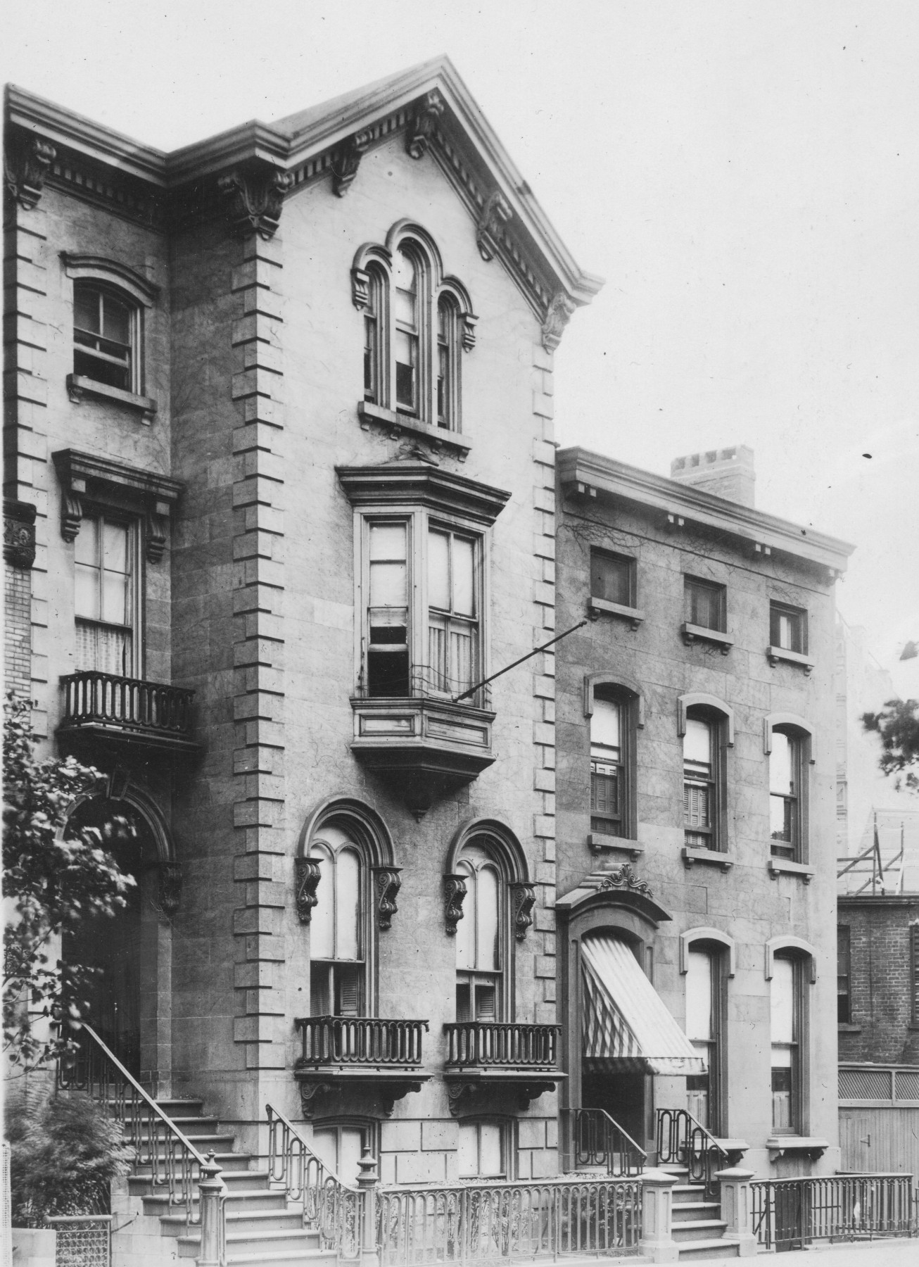
But as the 1960s progressed and the plans were implemented, it became clear that they were not working. As African Americans and Puerto Ricans who could not find the jobs that had moved to the suburbs and sunbelt replaced white ethnics, the cities became poorer, population fell, and urban renewal promised only sterility and segregation. A World War II era view of Pierrepont and Fulton Streets suggests the urban renewal swept with too broad a brush. It as a corner most of us would today see as charming. However, a comparison of the 1898 view entitled “Pierrepont Place, Leading to Columbia Heights” with the same view today highlights Robert Moses’ more democratic vision for the area at a time when the old aristocratic and exclusivity paradigm was gone. Pierrepont Playground has replaced the Henry Pierrepont Mansion, and the private park called Miss White’s Garden was replaced by a typical postwar buff brick twelve story apartment building in 1948. Aesthetically, the 1897 view is certainly superior.
Read Urban Renewal Part One
These posts are from Robert Furman’s forthcoming book “Brooklyn Heights: The Rise, Fall and Rise of America’s First Suburb,” to be published this fall. Preview copies are now available for $50.00 postpaid on CD as pdfs. Send check or money order to Mr. Furman at P.O. Box 23365, Brooklyn, N.Y. 11202. Be the first to see this important book!