Brooklyn Heights History: Baseball 1840-1958

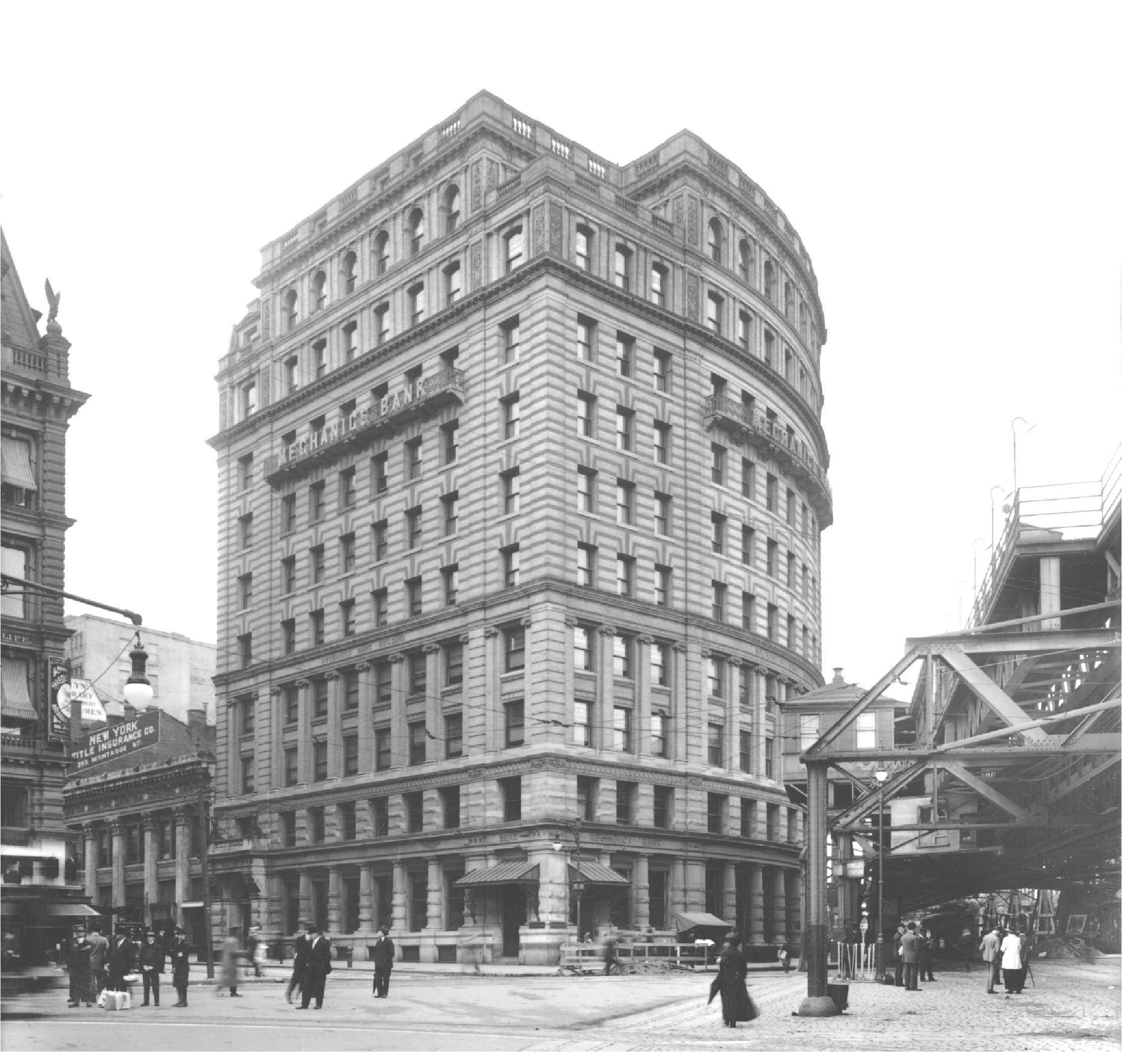
As part of urban renewal, the Mechanics Bank Building on the northwest corner of Fulton and Montague Streets, which had housed the Brooklyn Dodgers’ front office, was razed in 1958. History was made in that building with the signing of Jackie Robinson by General Manager Branch Rickey in 1947. The bank itself had been absorbed by the Brooklyn Trust Company, part of a continuing trend toward bank consolidation and of their going national and now, international.

Strangely enough, in the era of high rises, this notable ten-story structure was replaced by a four-floor building whose first tenant was the Brooklyn Savings Bank and still bears the chiseled inscription “Founded 1827,” a poor souvenir of what had been Brooklyn’s second oldest bank, begun in the Apprentices’ Library. Below this is a 1998 plaque that tells the story of Jackie Robinson and Branch Rickey integrating baseball.

The Dodgers held many of their annual dinners in the Hotel Bossert, including the one when they finally won the World Series in 1955. The Bossert wasn’t the Dodgers’ exclusive hotel for visiting players, many of whom stayed the Towers Hotel.

The major symbol of Brooklyn’s decline is the departure of the Dodgers for Los Angeles in 1958. The Brooklyn Trust Company, the team’s bank, is now the Chase branch at Montague and Clinton Streets. Their General Counsel, Walter O’Malley, although a civic leader (he was a vice president of the Brooklyn Club), and a major stockholder in the Long Island Railroad and Brooklyn Union Gas Company, came to own the Dodgers and move them. A proposal for a new stadium at Atlantic Terminal failed.

Walter O'Malley (l) with NY Giants owner Horace Stoneham hold model of proposed domed Brooklyn baseball stadium in 1957.

O’Malley demanded that the city build a new, larger stadium with adequate parking and deed it over to him, as L.A. had promised to do and eventually did. Robert Moses was uncooperative with using eminent domain to further private interests, and Mayor Robert F. Wagner felt the demands were extortionate and that if he had complied with them he would have been impeached! The city offered a new stadium in Flushing Meadow Park, which pleased neither Dodger fans nor O’Malley because it was in Queens, where the new National League New York Metropolitans would obtain a city-financed (but team owned) stadium in 1965.


This and the Brooklyn Trust branch are not the only Heights sites crucial to baseball history. A plaque on 133 Clinton Street notes that it was the clubhouse of the Brooklyn Excelsiors, an amateur club who were U.S. champions in 1860 when the sport was in its infancy and known as the “New York game.” They began its professionalization. According to the plaque, they began as the “Jolly Young Bachelors” and then the “Bride-grooms,” names redolent of the old aristocracy indicated by the membership of young men with names such as Pearsall and Polhemus. They eventually became the Dodgers, and the building and organization of the Excelsior Club became a social club by 1874 which persisted into the 1930s.

133 Clinton Street

BASEBALL. An Illustrated History by Geoffrey C. Ward and Ken Burns reports that the Brooklyn Excelsiors played the Atlantics for the championship of the City of Brooklyn on August 20, 1860. The Atlantics were a working-class nine and went on to become the dominant team of the 1860s. The Brooklyn Niagaras fielded baseball’s first star, James Creighton, who is credited with inventing the legal fastball. He later moved to the Brooklyn Stars and then to the Excelsiors. He died in 1862 of a ruptured bladder after hitting a home run. Another Brooklynite, William Cummings, came up with the concept of the curveball at age fourteen and went on in 1867 to beat a Harvard College team with this innovative pitch while playing for the Excelsiors. Another Brooklyn player invented the bunt.

Robert Furman is working on a history of Brooklyn Heights called “Brooklyn Heights: The Rise, Fall and Rise of America’s First Suburb,” to be published later this year.

Share this Story:

, , ,

  • eg

    I’m a bit mystified – where exactly would Montague and Fulton be on today’s map. the photo suggests Cadman Plaza West, but what the elevated trains. Exactly how old is Cadman Plaza and the court buildings?

  • http://selfabsorbedboomer.blogspot.com Claude Scales

    According to Osman’s Inventing Downtown Brooklyn, the elevated train lines, including the terminal that occupied the space that is now Cadman Plaza Park, had recently been demolished as of 1945. The court buildings were built in the late ’40s to early ’50s. My guess is that Fulton Street curved northward from where it now ends (the western end of Fulton Mall) and roughly followed the course of what is now Cadman Plaza West.

  • epc

    Montague & Fulton is Montague & Court or Cadman Plaza West.

    Conceding my newbieness to the neighborhood compared to others who post here…

    Cadman Plaza seems to date from the late 1940s to early 1950s, I don’t know the precise dates but there was a set of activities that involved shifting the Brooklyn Bridge approach away from Washington to Adams and creating Brooklyn Bridge Boulevard. Elimination of a number of cross streets (eg Nassau, High, not entirely sure Myrtle connected to Fulton or Washington). Destruction of various buildings surrounding what is now Cadman Plaza (on the west side where the Cadman Towers and Whitman coops are located, on the east side a number of low-rise commercial buildings).

    From what I can tell comparing old maps and current maps, Cadman Plaza West mostly follows the path of what was Fulton except for the area around where Fulton and Court would have connected.

    There were elevated train lines running from the ferry landing, connecting at approximately High Street to lines running over the Bridge and down either Nassau or Myrtle (the photo I have stops at “old” Adams so I can’t tell).

  • epc

    Found an 1897 map: Sands, High, Nassau and Concord were eliminated between Adams and Fulton/Cadman West, as well as Liberty which appeared to run from approximately where Main and Prospect would intersect to just short of Tillary. Myrtle appeared to dead end in an intersection with Fulton, Court and Montague. The south west corner where Court and Pierrepont intersect has been sliced off (fulton used to cut more sharply through what is now Columbus Park/plaza in front of Borough Hall).

  • bornhere

    epc — I was too young then to pay much attention then (and too old now to remember exactly) but Fulton Street in the Heights was destroyed to be replaced by the Cadman blah in the early 1960s.

  • bob furman

    Very good work by the commentators. Fulton ran east of Boro Hall to the intersection of Montague. (You can see its course by the subway grating.). The els were torn down in 1940 with the bridge station at Sands St also razed. The Cadman Plaza names (East is Washington St.) Were bestowed in the late 1930s and the courthouse was completed in 1960 when the old County Courthouse and Hall of Records on Joralemon and Boerum Pl were torn down. My book will contain a detailed history of the urban renewal which is too long for a blog post. I am amazed that the gorgeous Mechanics Bank building was scheduled for demolition in the 1930s simply because it was built in

    1905–in other words–it was old.

  • epc

    What is the building to the left of the Mechanic’s Bank (I’m guessing it’s where Bank of America is now)?

  • bob furman

    Montague was converting from residential to commercial in 1915 and lots of townhouse-sized business buildings.

  • bob furman

    Across Montague was the Continental Insurance bldg.

  • http://selfabsorbedboomer.blogspot.com Claude Scales

    epc: I enlarged the image and could read the sign on top of the building to the left of the Mechanics Bank Building. It says “New York Title Insurance Company, 283[?] Montague Street.”

  • bob furman

    The NY Title Insurance sign is at an angle to the building next to the Mechanics, suggesting it was on the side of a structure down the block.

  • Karl Junkersfeld

    For those who haven’t seen one of my earlier films about the building of Cadman Plaza, take a look. Not perfect but it was attempt to show what the area looked like. Again this is an early effort and I was just learning how to use the media. There are numerous pictures of the Fulton/Montague cross section.

    http://www.youtube.com/watch?v=2l_cztCwXhg

  • bob furman

    Karl. Do you have some original pictures or are they all from bpl and bhs. If so, I’d like to use some.

  • Karl Junkersfeld

    Don’t have the answer but I’ll provide some pictures from the time and hopefully you can figure it out. I want to know.

    http://www.youtube.com/watch?v=Sq4OT63QbP0

  • Karl Junkersfeld

    Bob,

    Nothing original. Just digitized pictures I found over the years.

  • bob furman

    Send any pictures that are not bhs or bpl to bobfurman1@juno.com.

  • 5w30

    RE: The New York Mets began play at Shea Stadium in April 1964.

  • fulton ferry res

    It is accurate to report that Cadman Plaza Park received its name in 1939; however, it was the massive urban renewal project (Cadman Plaza) in the North Heights, conceived in 1956 and begun in 1964 with demolitions along Fulton Street, that led to the streets being renamed Cadman Plaza West and East in1967.

  • Karl Junkersfeld

    Correct fulton ferry res. Just so people know, the original name in 1936 was Brooklyn Bride Plaza.

  • nabeguy

    Gee Karl, don’t you mean Bridge?

  • Karl Junkersfeld

    nabeguy,

    Glad you are still hanging around. It is so weird to see you beautiful house with the lights out with no cat or dog barking in the window.

  • bob furman

    Thanks all. The effort for Brooklyn Bridge Plaza goes back to Alfred T White and the BHA. In 1929 the BB plaza Assn planned a George Washington memorial arch for it.