I’m currently job hunting, and while writing resumes that no one will read is really exciting, I’ve decided to also take this (hopefully brief) time to do the things I wouldn’t normally have time to do if I had a job. I don’t have a particular agenda, just wherever the mood takes me. Perhaps you and I both will benefit from this. (Just don’t bet the house on it.)
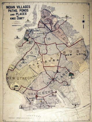
So here’s my first quest, inspired by a conversation I had with my friend, Liz—learn about the Native American trails that once served as the major arteries through Brooklyn. (I knew Broadway had first existed this way, but didn’t know about any in Brooklyn.) I went to the Brooklyn Historical Society, where a helpful librarian located this map, “Indian Villages, Paths, Ponds and Places in Kings County,” published in 1946 by then-Brooklyn Borough Historian James A. Kelly.
Since this is the Brooklyn Heights Blog, I wanted to concentrate on this neighborhood; however, I couldn’t help but notice the label “Indian burial ground” next to the tepee located in Boerum Hill. It raised a few interesting questions in my mind:
- Does the tepee cover the exact place where the Indian burial ground exists? (If so, it is directly over Wyckoff Gardens.)
- Do all the tepees represent Indian burial grounds, or just the one that’s labeled? (This map has no key; the librarian thought all the tepees were also burial grounds. I, however, think they just represent the settlements.)
- If all the tepees are burial grounds, then that means there is one beneath my building in Brooklyn Heights. This would perhaps explain the plumbing issues.
Interesting to see some of the trails that exist today as major thoroughfares, like Fulton Street, Flatbush Avenue and part of Atlantic Avenue. I have yet to uncover any information on the Ihretonga, which is the tribe listed as living in Brooklyn Heights. I did, however, learn that the Werpos village of the Indian burial ground had a twin village located around today’s City Hall.
One other site I noticed was a park extending from Columbia Street to Smith Street, and from Atlantic Avenue to Kane Street (and labeled as “Sassians” on the map). I guessed it was park of today’s Van Voorhees park, and indeed nycgovparks.org has more information.
Stay tuned for Part 2 of Since I’m Not Working: Native American Edition, where I travel one of the Native American trails, and also try and get answers to the above questions. And now I’m off to the 8-4 for the police blotter. See you there.