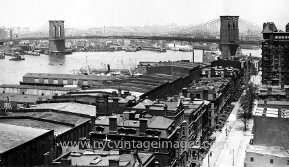
Heights History: A Magnificent 1905 View Looking Up ‘Columbia Street’

This wondrous 1905 image shows Brooklyn Heights looking northwest up what was then known as Columbia Street. The background reveals nearly the entire span of the Brooklyn Bridge. In the upper right corner of the photo is the renowned Hotel Margaret, between Orange and Cranberry Streets, which was built in 1889 as the neighborhood’s “first skyscraper”; unfortunately, it burned down during a 1980 renovation.

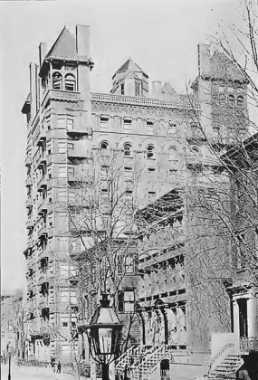
(Photo: NYC Vintage Images) Below, the Hotel Margaret…
Share this Story:

, , , , ,

  • epc

    There’s a similar shot from 1908 on Shorpy: http://www.shorpy.com/node/3893 but in much higher resolution.

  • epc

    I thought this shot http://www.nycvintageimages.com/category/tags/brooklyn-bridge#node-213 was more interesting. It’s a view from the Brooklyn tower looking south east over downtown Brooklyn in 1909, pre-BQE and Cadman Plaza “renovations”. Wondering if anyone knows/remembers the church which appears to be on Hicks about two lots up from Fulton? Interesting also to see the line of commercial/residential buildings along Old Fulton (which are now parking lots and eventually green space for BBP).

  • Nicholas Post

    Made sense, I grew up in Brooklyn Heights from 1956 to 1976. I walked down that area and I wondered why there was a big empty lot.

  • Nicholas Post

    epc,
    Cool vintage pix, especially perfect top center view. I could see pre-Promenade!

  • Nick A

    rebuild the hotel margaret!!!!

  • Jeremy

    Good eye EPC. That’s 13 Hicks Street.

    Here’s what google has to say:

    1895 book titled “Nickerson’s illustrated church musical and school directory of New York and Brooklyn” calls it the “Bethel Chapel of Plymouth Parish” which is confirmed by a 1880 map showing “Plymouth Church Bethel” and a 1898 map that shows “Bethel of P.C.”

    At some point later the church was acquired by the Jehovah’s Witnesses in their early days here (when they called themselves the People’s Pulput Association), and called the building the Brooklyn Tabernacle: http://www.biblestudents.com/htdbv5/r4395.htm

    Apparently the Witnesses sold the property after a crackdown on pacifists during World War I, which included a raid on this building. This July 1918 New York Times headline sums it up: “RUSSELLITES SELL HOME; No Use for Headquarters Since Leaders Went to Jail for Sedition.”

    A book titled “The Iron Age” says in August 1918 the site was bought the Cameron Machine Co. on 61 Poplar Street to be used for an extension of its manufacturing.

    Christopher Grey, handicapped mightily by a lack of the Internet but still performing well, came up with this in the September 10, 1989 edition of the New York Times: “Q. Before World War I, there was a big red brick church at 13 Hicks Street, in downtown Brooklyn. It was later converted to a machine factory, which expanded its plant to eliminate a little alley in back. The entire complex was razed in the late 40’s for highway construction. What was the church and what was the name of the alley? . . . Manuel T. Murcia, East Greenbush, N.Y. A. It was the Romanesque-style Brooklyn Tabernacle, a Presbyterian Church. A 1912 land map identifies the alley as both Poplar Place and Buckbees Alley.”

    I will one-up Grey because I happen to know that Buckbee’s Alley is the original name, later changed to Poplar Place. Buckbee ran a grocery at the corner of the alley and Fulton Street in the early days of the Village of Brooklyn (c. 1816). Here’s what Henry Stiles records for posterity about Buckbee: “Buckbee sold very poor liquor, and himself and customers were no ornament to the society of the village.” I can’t remember the source (perhaps also Stiles) but I recall reading that Buckbee was a nasty SOB who was shot and killed by his own son.

  • Amanda

    I’m trying to understand the before (photo) and after (BQE/Promenade/BBP), given that it says the hotel was around after the BQE. From the photo, it looks like the hotel is on the lower elevation. Would someone either explain or point me to a good place to understand better? Thanks.

  • Karl Junkersfeld

    Jeremy,

    You are the most knowledgeable individual in the world when it comes to the history of the Northern Heights. I wish you had the time to put it on paper. What an incredible reservoir of information in that brain of yours. Amazing. I bow in admiration.

  • epc

    In the top photo, Columbia Heights runs from just right of center at the bottom to the upper right. The Margaret is the tall building in the upper right. The warehouses along Furman may look level with the houses on Columbia which can be disorienting.

  • epc

    Interesting find about Buckbee’s Alley. I’d read that there was a Duckbees Alley in the same general area but the map I saw was never quite clear about that first letter.

  • Danno

    My question: where was the photo taken *from*? It could be from the top of 62 Montague, which is 10 stories tall, was built in the late 1880s (the neighborhood’s first elevator building) and is close enough to what’s now the foot of Columbia Heights to make the picture’s angle possible.

  • Amanda

    Thanks, epc. Yes, now I can see that the warehouses are not really on the same level, but they certainly look like that without looking so closely. thanks, again.

  • http://www.flickr.com/photos/13189502@N02/ Eddyenergizer

    Danno, I think its too far north to be 62, my guess it was taken from the Standish Arms Hotel.

  • WillowtownCop

    I always thought it was perfect to have Columbia Street, Place, and Heights. The beginning of Columbia Street is the Red Hook projects – an easy way to know if you’re upper (Heights), middle (Place), or lower (Street) class.

  • Nabeguy

    epc, looking to the far right of your photo, you can spot the spanking new PS 8 building, which had just been completed in 09. The building with the 3 water towers is the Mason Mints Building at 20 Henry, and the one with the Gillette ad on top ot it Ilooks to be the old Newsboys Home on Poplar.

  • Nabeguy

    By the way, here’s a great link for any budding Brooklyn historians out there. It includes the Stile’s history that Jeremy mentions, as well as other ephemera http://www.bklyn-genealogy-info.com/index.html

  • Elmer Fudd

    There is a scene in the movie “Taxi Driver” taken from inside the Hotel Margaret – over looking the piers and East River. It is the scene where Travis Bickers buys the guns from the dealer. (1976)

  • Andrew Porter

    epc, thanks for the Shorpy link! That photo includes the western edge of 45 Pineapple, before it was reconstructed in the 1930s to take out the rounded windows, cornices, fireplaces, etc. 45 and 55 were fairly ordinary commercial apt buildings which otherwise do not appear on photos, so tracking their original appearance is often fruitless. One of their two claims to fame: they were the final home of Henry Ward Beecher, who had a direct line of sight to his church on Orange Street.

  • epc

    I like that shot (from Shorpy) also for showing what Willow was like between Pineapple and Clark before the Leverich Towers was built.