On This Day: April 12, 1816, Brooklyn Became a Village

On April 12, 1816, New York officially incorporated the village of… Brooklyn. The State of New York legislature passed an act of incorporation on this day—with the participation of Brooklyn Heights founding father Hezekiah B. Pierrepont—that gave Brooklyn its first charter, establishing its official boundaries.

Among the primary regions defined was Brooklyn Heights, which the Brooklyn Eagle says was once known as Clover Hill, and before that “Ihpetonga,” a Native-American name meaning “a long sandy bank.” The area was renowned for its fine fruits and vegetables, which were popular for sale in Manhattan. “There were waving fields of grain, orchards of apple, peach and plum trees, huge vegetable gardens and berry patches.”

The first boundaries of Brooklyn, according to the village charter: “Beginning at the public landing south of Pierrepont’s distillery, formerly the property of Philip Livingston, thence running along the public road leading from said landing to its intersection with Red Hook Lane, then along Red Hook Lane to where it intersects the Jamaica Turnpike, thence a northwest course to the Wallabout Millpond, thence through the center of the millpond to the East River, and thence down the East River to the point of beginning.” Um, did you follow all of that?

The Brooklyn Eagle, adds, “Meeting after meeting had been held at Hezekiah B. Pierrepont’s residence and at various taverns scattered throughout the area. Once incorporated, farms could be opened up and residences (could) take the place of orchards and gardens.”

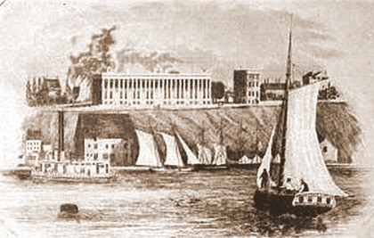
(Photo: Colonnade Row from an 1840 engraving of Brooklyn Heights, built in 1837 by General James E. Underhill. It burned down in 1853./Brooklyn Daily Eagle)

Share this Story:

, ,

  • epc

    More info about Colonnade Row for the curious: http://www.whitmans-brooklyn.org/2008/06/underhills-colonnade/

  • Jeremy

    The Town of Brooklyn had been in existence far earlier than the village’s incorporation date. The town’s boundaries were a large chunk of northwest Kings County.

    The village’s boundaries are pretty easy to follow. The “public landing south of Pierrepont’s distillery, formerly the property of Philip Livingston” is basically where Pier 6 is today. The “public road leading from said landing to its intersection with Red Hook Lane” is the road that became District Street, later renamed Atlantic Avenue. Red Hook Lane ran northeast from that road, crossing between where Court Street and Boerum Place are today – and part of Red Hook Lane still survives between Boerum Place and Fulton Street (which is the Jamaica Turnpike). Then a straight line to the north through what is now the Navy Yard to Wallabout Bay, and then wrapping around the East River through what is now the river’s edge in Vinegar Hill, Dumbo, Fulton Ferry Landing and Brooklyn Heights back to the beginning.

    This 1827 map shows it pretty well (although not all these streets were laid out in 1816):

    http://tinyurl.com/75k4ahr

    The Eagle isn’t quite accurate in its chronology of development. The Hicks brothers had already subdivided their farm into development lots starting in 1806, ten years before incorporation. Pierrepont had a better eye (or luck) for timing and marketing of his development, though – the Hicks bros. sold off most of their land to small-time business owners like coopers and blacksmiths who serviced the local community, but by the time the village was incorporated, Fulton’s steam ferry to Manhattan had started and Pierrepont sold off his land to merchants who start building much more elegant houses in Brooklyn Heights and commuted to Manhattan.

  • Livingston

    Thanks for the “translation”, Jeremy. I pass through Red Hook Lane frequently and always thought the odd little alley was probably a remnant from the past. Now I know!

  • http://www.flickr.com/photos/13189502@N02/ Eddyenergizer

    I remember being told when I was a kid, Red Hook Lane was the oldest street in Brooklyn.

  • http://selfabsorbedboomer.blogspot.com Claude Scales

    This story is probably in the “too good to be true” category, but I did hear it on a walking tour. It goes like this: before selling off their land, the Hicks brought their produce, known for its high quality, by boat to the Manhattan side where there was a farmers’ market. People standing on the shore would see the boat cast off from the Brooklyn side and call out, “Here come the Hicks!” This is the origin of farmers being called “hicks.”